Excerpts from Celestial Navigation Without Almanacs
 Celestial Navigation — Introduction
What do most sailors want from celestial navigation? A backup to their GPS system, in case it fails, that is accurate to within a few miles, so they can find their way back to land, that’s all. If you are on your way to Hawaii, and you lose all your electronics in a storm, you want to be able to use your sextant and mechanical wind-up watch or clock to navigate to Hilo Bay accurately enough that you are very sure you won’t miss the big island entirely. Having to learn all the complexities of classical celestial navigation, and buy multiple volumes of sight reduction tables and new almanacs each year, is an overkill for this purpose, and very few sailors actually do it.
What I’ve developed for this purpose, in the form of this slim book, is a simple set of navigation tables, including a year correction table up to the year 2050 and instructions on how to extend it for at least the next 100 years. With this book, and its latitude and longitude worksheets, you can take noon sightings with your sextant, note the UT (GMT) on your watch or clock at the time of the noon sighting, and calculate your position to within a nautical mile or two in latitude, and a few nautical miles in longitude. If you practice the method in advance, and check it against your GPS position, you should easily be able to achieve this accuracy. Nautical almanacs are not needed. All the sun and star tables you will ever need are in this book. . .The tables in this book have been compiled from data published by the US Naval Observatory, including their “Multiyear Interactive Computer Almanac” and their web pages “Celestial Navigation Data for Assumed Position and Time” and “Sun and Moon Rise/Set Table.”
How GPS Could Fail You
Like me, you probably carry a portable GPS as a backup to your GPS plotter, and keep it in your abandon ship bag, wrapped in aluminum foil so it’ll be less likely to have its electronics fried if lightning strikes your boat. And maybe, like me, you still have a Loran C on your boat. Surely, with all this backup (and perhaps a second portable GPS stashed away somewhere), you would always have a way of finding your position electronically?
But what if you have a severe lightning strike, and ALL your electronics fail, despite your attempts to shield some of them by putting them inside metal cans, or wrapping them in aluminum foil? One can buy rather expensive celestial navigation calculators, that are easy to use and contain all the nautical almanac information for many years to come, but these, too, are likely to fail in such a lightning strike.
And what if the US government decides to turn the GPS system off for security reasons, such as if it were at war in a critical situation? The US military operates two parallel GPS systems (though they both use the same satellites), one for its own exclusive use, and the other one we all know, that it shares with the world. It is obvious that the US military could gain an important strategic advantage over an enemy relying on the shared GPS system we use, if it turned this system off, as it still has its own exclusive GPS system it could use. Most likely, that’s why they have two parallel systems. If they could never foresee a reason to turn one of the systems off, why have two systems? This seems to me to be a good reason for having a back up celestial navigation system one can use. Also of concern are reports that the US government is well behind schedule in the expensive process of replacing the GPS satellites. A financially bankrupt USA might have to let the GPS system slip away. This means we could, at some point, be facing a future without GPS.
Sunset Method for Finding Longitude
If you can time sunset in UT (or sunrise, for that matter) you can use Table 17 (p.49) to get your longitude to within about 10 NM if you know your approximate latitude (to the nearest degree or better), perhaps from using the small angle method with a star.
The time of sunset is when the last spec of the sun’s upper rim disappears — when that last bit of golden brightness winks out. Sunrise is, likewise, when the first spec of the golden brightness of the sun’s upper rim is noticed.
Let’s use an example to show how to find your longitude by sunset time. Say you are at about 28°N on July 17, and you time the sunset to be at UT 05h 10m 30s (tomorrow in Greenwich). This is the time you measure on your watch, corrected for however fast or slow it may be, so it is as close as you can get it to exact UT. Since it is a time tomorrow, add 24 hrs to it to get 29h 10m 30s. Table 17 shows, on page 51, that the sunset time at your latitude of 28°N at 0°W is UT 18h 58m (1858). Subtracting this from your sunset time, you get a time difference from 0°W of 10h 12m 30s. Longitude is just time difference from Greenwich longitude, as we know from the different time zones around the world. This means this time difference from 0°W is your longitude. Convert it to degrees by using the fact that 24h = 360°, 12h = 180°, 6h = 90°, 1h = 15°, 4m = 1° and 1m = 15’. In this example: 10h = 150°, 12m = 3°, 30s = 7.5’ (8’), making your longitude W153° 8’. The longitude is West if you are behind UT — in other words if the UT you time the sun setting at is later than the time in the table for 0°W. In a worksheet form, these calculations are:
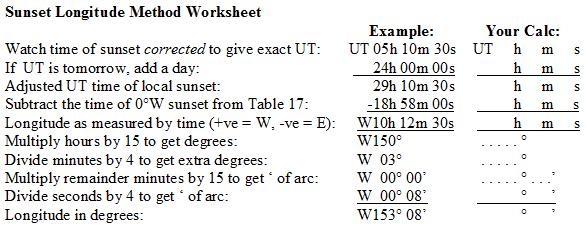
An excerpt from "Table 17: Day Length (hhmm) and Sunset (UT@0°W) for Declinations 54N to 45S. Get Sunrise by Subtraction." The entry used for the above calculation is circled in red:
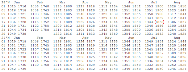
Except for the two weeks either side of the equinoxes, Table 17 can also be used to get your latitude if you time sunrise and sunset to get your day length (and adjust it for distance sailed east or west). This is because, other than at times close to the equinoxes, day length varies considerably with latitude. In the above excerpt from Table 17 you can see that in July there is about a four minute difference in day length between latitudes 27°N and 28°N. Celestial Navigation Without Almanacs fully explains, with examples, how to get your latitude this way.
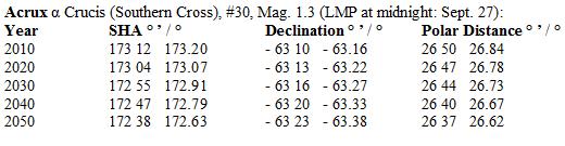
Next is one of 36 sets of star positions in Tables 10 and 11, that show how the star positions change between 2010 and 2050. This is the entry for Acrux that was used to get the Polar Distance of Acrux in the fictional account "Lost at Sea Without GPS":
Conclusion
This book deals with the “celestial” part of navigating without GPS — and even without a sextant — and, unlike GPS, it can often be a few miles out in determining your position. Fortunately, you can, like the ancient Polynesian navigators, tell when you are coming close to an island, or a coastline, and determine the direction toward land, by a variety of other signs such the presence cumulus clouds over islands, green reflections off clouds over atoll lagoons, and the presence of birds flying back to land around sunset from up to 100 miles out to sea. Sometimes you can even follow planes coming in to land at the island you are heading for. Also, you can tune in to an AM radio station broadcasting from your destination and use the radio’s internal antenna to point your way in (when the antenna, which usually runs along the top of the radio from side to side, is aligned toward the station the signal will fade and die off). I encourage you to be observant and notice these signs that land is approaching as you cruise with GPS and practice the celestial navigation described in this book. Such mindfulness, along with proficiency in the techniques of this book, will serve you well in navigating in a future that may end up being without GPS.
Table of Contents (67 Letter-size pages)
Celestial Navigation — Introduction
How GPS Could Fail You
What Else Will I Need Apart from this Book?
Part I: Sextant Methods
How To Do Celestial Navigation From Noon Sights
Understanding How To Find Latitude
Latitude Worksheet, Part A
The Noon Sun Sight
Preparation and Safety and Checking the Index Error
How To Make a Sun Sight
Making the Noon Sight
Latitude Worksheet (Part B)
Understanding Longitude (and Worksheet Part A)
Longitude Worksheet (Part B)
How to Estimate the UT of Your Local Noon
Other Ways to Determine Latitude and Longitude from the Sky
Dead Reckoning
Polaris Sights
1) Getting the Polaris Angle
2) Getting the Polaris Distance and Altitude Correction
3) How to get your Latitude from a Polaris Sighting
Getting Latitude from Stars in the Southern Hemisphere
A Southern Star Example
Determining the Local Hour Angle (LHA) of a Star
Part II: Non-Sextant Methods of Celestial Navigation
The Small Angle Estimation Method for Finding Latitude
Estimating Angles Accurately
Using Binoculars to Measure Small Angles
The Formula for Lower Meridian Passages
Upper Meridian Passages in the other Hemisphere
Working out When a Meridian Passage will Take Place
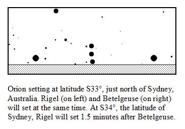
Setting Star Pairs Method of Finding Latitude
Sunset Method for Finding Longitude
Day Length Method for Finding Latitude
How to Deal with Certain Emergency Situations
1/ You’ve lost track of the current date
2/ You’ve lost track of UT
Conclusion
Part III: Tables and Worksheets
Table 1: Vernal Equinoxes and Year Corrections
Table 2: Longitude Correction and Solar Declination
Table 3: Atmospheric Refraction
Table 4: Dip
Table 5: Solar Parallax
Table 6: Sun’s Semi-Diameter
Table 7: Angle of Star to Mirfak via Polaris
Table 8: Polaris: Distance from Pole, Angle to Pole
Table 9: Polaris: Altitude Correction
Table 10: Positions of 16 Southern Stars
Table 11: Positions of 20 Northern Stars
Table 12: GHA Aries on Jan 1, 00:00:00 UT
Table 13: Easy Way to Multiply by 0.985647
Table 14: Cosines (cos) of Small Angles
Table 15: Great Circle Angles Between Stars
Table 15a: Positions of Some Non-Polar Bright Stars
Table 16: Phases of the Moon: First Quarter and Last Quarter
Table 17: Day Length and Sunset Times
Table 18: Twenty Nine Close Setting Star Pairs
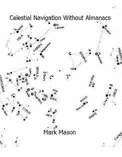
Chart of Navigation Stars
Latitude Worksheet, to photocopy
Longitude Worksheet, to photocopy
Sample Latitude from Day Length Graph, worked through
Blank Latitude from Day Length Graph Sheet, to photocopy
Sample Interpolation for Sunset Method Graph
Graphical Multiplier and Divider
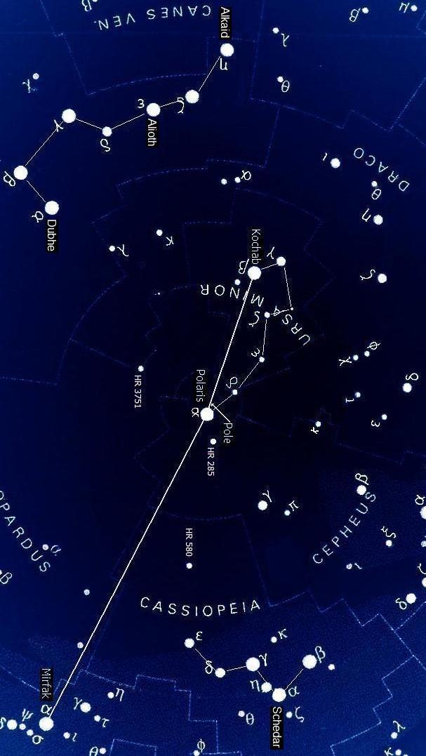
North Polar Star Chart
A diagram and caption from the book helping to explain the "Setting Star Pairs of Finding Latitude":
A part of the North Polar Star Chart on the back cover of the book:
|
|
|
|
If you are interested in celestial navigation, you may also be interested in my cosmology theory. If you would like to read about it, please click here: Universal Field Cosmology
Click here for the home page of my book, In Search of the Loving God, which includes three complete chapters from the book:
In Search of the Loving God